Client: Ministry for the Environment
Natural wetlands are productive habitats for a variety of flora while providing a wide range of ecosystem services. They are also one of the most threatened ecosystems on earth.
In New Zealand, wetland delineation has been undertaken using a variety of different methods, resulting in variable resolution, accuracy and completion across the regions.
From 2002, several geospatial databases containing wetland information have been developed including the Landcover Database (LCDB), Wetlands of National Importance (WONI) and Freshwater Environments of New Zealand (FENZ), while most regional councils also maintain local inventories. In general there is a lack of consistent delineation of wetland extent which has impeded national reporting and protection.
In late 2020, Morphum Environmental and Lynker Analytics were awarded a contract by the Ministry for the Environment in New Zealand to develop a new method to identify and map natural wetlands in a semi-automated way, using Artificial Intelligence (AI). We are now mid-way through this project.
Our research began with an exhaustive analysis of nearly 200 national and international published studies into wetland mapping spanning field survey and photo interpretation, remote sensing, decision trees and neural networks.

Typical remote sensing inputs used in wetland mapping. Topographic Wetness Index (TWI) (left) and Normalized Difference Water Index (NDWI) (right)
This showed that despite the many advances in Remote Sensing technology, automated wetland classification remains a challenging task as wetland and non-wetland classes exhibit similar spectral and/or backscattering information in satellite or airborne imagery.
Practitioners have turned increasingly to Machine Learning (ML) methods in recent years where Decision Tree models such as Random Forest, Gradient Boosting and XGBoost have produced higher accuracies than Remote Sensing alone.
In the last five years Convolutional Neural Networks (CNNs) have been used with slightly greater accuracy levels than the other methods. CNNs allow multiple inputs to be considered including imagery, topographic indices, and composite remote sensing indices such as normalised wetness index and normalised vegetation index.
The research also showed that Machine learning models are often a few orders of magnitude faster than other physically based (deterministic) models. However, there are also not many examples of wetland mapping using ML at scales less than 1 ha.
With a relatively small geographic area and positive open data government policies, New Zealand is fortunate to hold high resolution ortho-photography for every region. Many regions have sub-metre RGBI aerial photography with the infrared band very useful for automated wetland classification. Additionally, LiDAR data stocks have been steadily rising across New Zealand thanks to collaborations between councils and Land Information New Zealand.
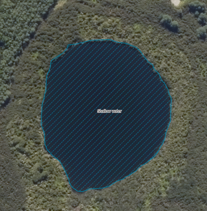
Shallow Water Wetland delineated with Machine Learning.
The combined project team has now switched gear to focus on the development of a multi-stage machine learning proof of concept to identify, delineate and classify wetlands which will be applied and verified in two regions of New Zealand.
This approach will test several machine learning methods developed with high resolution vertical aerial photography, LiDAR and derivatives such as TWI and medium resolution Sentinel-2 multispectral imagery. An example of the preliminary model output is shown above for a shallow water wetland.
Given the generally higher accuracies of ML approaches and the relatively high resolution and availability of input data within New Zealand it is anticipated that this approach will enable more consistent and accurate results than previous remote wetland mapping efforts. The project is scheduled for completion by June 2021.
Deliverables:
Technical Report including literature review, data discovery and recommended approach to identify, delineate and map wetlands at large scales in New Zealand.