Client: Walton Family Foundation
In many parts of North America, beavers reliably and economically maintain natural wetlands by creating dams that trap sediment and slow the flow of water. After decades of trapping these skilled ecosystem engineers for their pelts, beavers are now valued for their ability to restore aquatic habitat, enhance riparian ecosystems and improve the reliability of water supply.

Inactive beaver pond located along the Crystal River in the Roaring Fork watershed of Colorado. Photo Credit: Sarah Marshall
As part of their 2025 Environment program strategy, the Walton Family Foundation funded Lynker Technologies, Lynker Analytics and the Colorado Natural Heritage Program (CNHP) to provide a comprehensive inventory of wetlands and beaver activity across the US portion of the Colorado River Basin. An initial map has now been published which adds to existing wetland mapping in the basin from the National Wetland Inventory (NWI).

Colorado River Basin Dynamic Mapper
In this project Machine Learning (ML), remote sensing and GIS were integrated to handle the large volume of data with imagery sourced from the National Agriculture Imagery Program (NAIP) administered by the U.S. Department of Agriculture.
Wetland delineation and classification was undertaken using semantic segmentation via a Convolutional Neural Network (CNN) while beaver pond identification was carried out using an object detection model. Both models were trained using extensive labelled examples from experts within CNHP spanning over 300 square miles of wetland area and covering more 20,000 ponds.

Object Detection - Beaver pond training
The CNN model used to generate the wetland area maps achieved an overall F1 score of 0.815.
Beaver activity areas (complexes) were identified through the spatial relationship of modelled ponds with modelled wetland area while a final wetland area is defined through multi-year analysis of the data across three separate NAIP surveys. Wetland experts at CNHP provided final quality assurance and review over the entire data set.
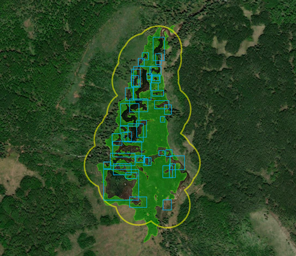
Example beaver activity area (yellow polygon), ponds (blue boxes), wetland (green polygons)
For the Upper basin, the model predicted wetland acreage similar to, and sometimes higher than comparable wetland and open water classes in the NWI. In the Lower basin, the model generally predicted lower total wetland acreage values than the NWI. Underprediction in the lower basin may be attributed to a combination of model performance and challenges associated with mapping dry-end wetlands in drought conditions.
Over 40,000 beaver ponds were identified in the Colorado River basin and we were able to verify new beaver activity areas in three states (Arizona, New Mexico, and Nevada) which had no previously mapped beaver-influenced wetlands within the basin. New beaver activity areas were also detected in Colorado, Wyoming, and Utah.
Although the results were sufficiently accurate to identify beaver activity in the basin, there is still more model development required to consistently detect beaver ponds and surface water. We have an ongoing programme of work which is concentrated on improving model accuracy to map wetlands and surface water using better and more varied inputs including satellite imagery and LiDAR.
Project deliverables include basin-wide geospatial data including:
Vegetated wetland area
Verified beaver activity areas
Summary data covering beaver activity areas, number of modeled beaver ponds within verified complexes, and an estimate of total beaver pond area by HUC10 watershed
The web based map viewer is available at: https://csurams.maps.arcgis.com/apps/webappviewer/index.html?id=2fa3527926d2415d8ea0786838b712bd