Client: Greater Wellington Regional Council
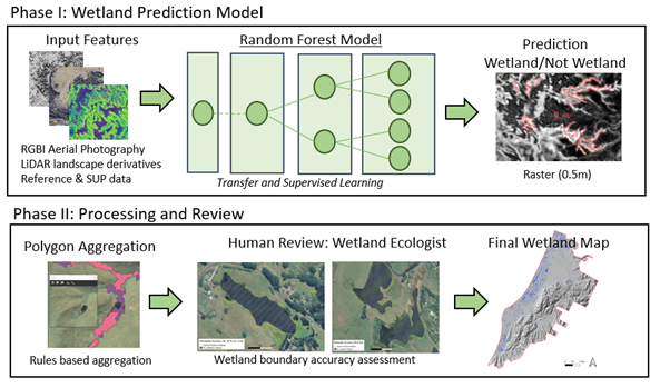
Environmental science and engineering specialist Pattle Delamore Partners (PDP) and data science specialist Lynker Analytics produced the first high-resolution wetland detection map of the Kapiti Coast using Machine Learning (ML), Light Detection and Ranging (LiDAR) and high-resolution Red-Green-Blue-Infrared (RGBI) aerial imagery. The wetland detection map was designed to provide the initial response to the need for wetland mapping in the Kapiti Coast District for the Greater Wellington Regional Council (GWRC).
The Challenge
Detect and map wetlands 0.05ha and greater including coastal wetlands in the Kapiti Coast District
Provide an actionable wetland output to help with the prioritisation of wetlands at risk of loss of extent or values
Develop a cost-effective method to detect and map wetlands for potential application across the wider Wellington Region
Background
The National Policy Statement for Freshwater Management 2020 as part of the essential freshwater reforms require Regional Councils to identify and map every natural inland wetland in their regions, outside of public conservation lands or waters, that is ≥0.05 ha by 2030. Furthermore, the policy statement provides direction that in doing so, regional councils should prioritise wetlands at risk of loss of extent or values. Given the risks to wetlands posed by urban development plans for the Kapiti Coast District, the timing of work on the whaitua catchment committee plan, and the spatial resources available, the Kapiti Coast District was selected to trial the new wetland detection techniques.
Internationally the task of wetland mapping had been described as one of the most difficult landscape features to map. Wetlands are dynamic and often transitional ecosystems; their interface with terrestrial and aquatic ecosystems are challenging to understand. Expert knowledge is normally required for designing and extracting the most efficient information and to discriminate wetland characteristics. To address this challenge our core team consisted of wetland scientists (including council specialists), remote sensing scientists, data scientists and geospatial specialists.
Several machine learning models were explored with a Random Forest decision tree method chosen based on performance and the ability to tune model inputs carefully based on feature importance. Active Learning was used to train the machine learning models; a methodology used to achieve high accuracy models using only the most essential training inputs.
RESULTS
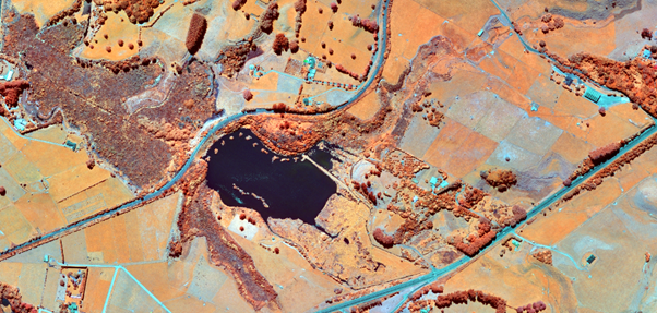
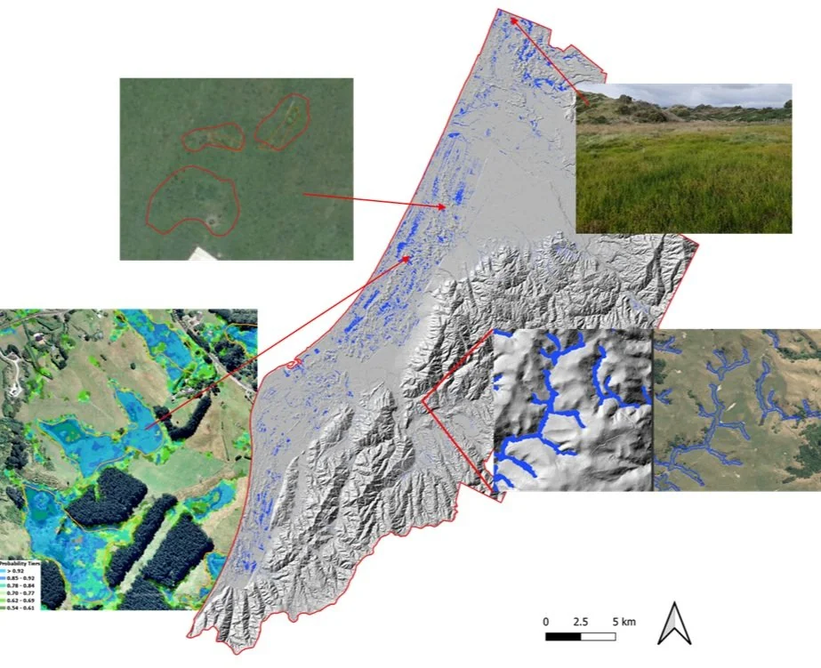
With this approach our team have been able to detect wetlands within the district in a very short time frame (3 months) compared to conventional methods. The results of the assessment are summarised as follows, including some illustrative images.
Average ML model accuracy was 86%
Average delineation accuracy of 78.6%
Detect wetlands of 100 m2 and larger
Mapped coastal including inland freshwater wetlands
Detected difficult detectable wetland types
Derived wetland likelihood tiers
THE OPPORTUNITIES
This approach provides a basis for prioritizing wetlands at risk of loss of extent or values. It is a very cost-effective method that can also utilise freely available regional imagery and training data from other regions may provide a head start and even a cost saving when transfer learning is applied. This approach can be applied region wide and further afield. Additionally, the outputs are a very valuable information source that can guide resource consenting and environmental planning. It provides an understanding of the spatial extent and connectivity of wetlands on a landscape scale and serves as a very valuable resource for the identification of potential wetland restoration areas.
Marinus Boon, Service Leader – Environmental Remote Sensing, PDP
Matt Lythe, Managing Director, Lynker Analytics